
The Upper Engadine is one of those places where I feel instantly at home. Not sure what it is, but as soon as I pass the Albula tunnel I feel very much at easy and totally relaxed.

The region of the Upper Engadine offers tons of great activities and sceneries, however one of the main reasons to come here basically any time throughout the year, are the fantastic hikes with unbeatable views, stunning mountain lakes and pure nature.
Thus I am listing my personal top ten hikes with a short explanation about route, length and fitness level in the following:
1 LAGO DI SAOSEO & LAGH DA VAL VIOLA

DETAILS
Type of Hike Roundtrip
Start / End Sfazù Fermata
Duration ca. 5.30 hrs
Length ca. 15 km
Ascent / Descent ca. 685 hm each
Difficulty medium (T2)
Lago di Saoseo is stated as one of the most beautiful mountain lakes in Switzerland, due to its amazing water colour and stunning reflections. Especially in autumn, the colouring contrast of the golden larches and the turquoise-blue water is incredibly beautiful. When we visited mid-October, the lake was already frozen though, so no reflection for us. But it was still a breathtaking scenery!
This well-known hike is located in the Val Poschiavo. The starting point Sfazù is accessible by private car or public bus (get off at Sfazù Fermata). For those who want to shorten the hike, there is even the possibility to change to a smaller public bus, which brings you all the way to Rifugio Saoseo (bus stop Lungacqua). However, make sure to make a reservation for this last leg (at least one hour in advance).
The beginning of the hike is not very spectacular, as it leads you along a wide forest road for about an hour, all the way up to Rifugio Saoseo. From there, the path becomes much more beautiful and narrows into a hiking trail which meanders through lush larch and pine forests and across open mountain plains. From the Rifugio it only takes about 15 to 20 minutes until you reach the first highlight, Lago di Saoseo. If you bring your own picknick, this is a great place to have lunch and enjoy the stunning views over the lake.
The following section is the most exhausting one, all the way up to Lagh da Val Viola. The first part of the ascent leads you again through forest, the second part is a bit more of rock-scrambling, and especially challenging when already partially covered with snow and ice. However, you will be rewarded with the most amazing view over Lagh da Val Viola, embedded in golden larch forests (in autumn).


From Lagh da Val Viola, allow for another 1.5 hours to get back to Sfazù along the direct trail.
2 FUORCLA SURLEJ

DETAILS
Type of Hike Oneway
Start / End Pontresina, Train Station / Murtel, Corvatsch, Cable Car Station
Duration ca. 4.45 hrs
Length ca. 13 km
Ascent / Descent ca. 1000 hm / ca. 100 hm
Difficulty medium (T2)
The hike to Fuorcla Surlej has several highlights included, such as a dreamy valley, amazing mountain and glacier views as well as a perfect mountain lake.
When starting in Pontresina, the first part leads you along the mostly flat trail through the enchanting Val Roseg. If you start early in the morning, expect to walk quite a bit in the shadow though, as the valley is rather narrow. Once you get to the end of the valley, it opens up to stunning views over the Bernina mountain massif. In autumn, the contrast between the golden larches and the snow-covered mountains in the back makes it to one of the most pristine landscapes to me.
Just before reaching the Hotel Restaurant Roseg Gletscher, take the path to your right, which is ascending quite steeply for the next 2 hours. However, with every step further, you will get a better view of the surrounding mountain scenery. It's one of the most stunning panoramas in the Alps.
After the strenuous ascent, you will reach the Fuorcla Surlej with the most rewarding view over the Bernina mountain massif. The mountain chains' reflection in the small lake is simply breathtaking. Take your time to enjoy the alpine scenery and to fuel up (either with your own picknick or by having lunch at the Berghaus Fuorcla Surlej).


You will only need another 45 minutes to get down to the Murtel cable car station, from where the cable car brings you all the way down to Silvaplana.
Tip: To shorten the hike you can book a horse carriage from Pontresina to Hotel Restaurant Roseg Gletscher.
3 LEJ DA STAZ

DETAILS
Type of Hike Oneway
Start / End Punt Muragl / St. Moritz Bad
Duration ca. 1.20 hrs
Length ca. 5.5 km
Ascent / Descent ca. 130 hm / ca. 80 hm
Difficulty easy
The short hike to Lej da Staz is the perfect activity to enjoy a relaxing, sunny afternoon outdoors, suitable for all fitness levels and even doable with a baby stroller.
From the train station Punt Muragl, it is an easy stroll through the larch forest without mentionable ascents. In the summer, the trees provide shade from the hot sun, in autumn they burst with colour and in winter it feels like walking through a snow-covered fairytale forest.
Once you reach the lake you can either enjoy a drink on the sunny terrasse of the Hotel Restorant Lej da Staz or simply relax on the shore of the lake. There are wooden piers, perfect for taking pictures, as well as several barbecue areas for a nice evening with friends. Especially when it is windless, the reflections are some of the best!


Once you soaked up all the beauty, it's time to circumnavigate the lake and to follow the path towards St. Moritz.
4 MUOTTAS MURAGL - CHAMANNA SEGANTINI - ALP LANGUARD

DETAILS
Type of Hike Oneway
Start / End Muottas Muragl / Alp Languard
Duration ca. 2.30 hrs
Length ca. 6.5 km
Ascent / Descent ca. 420 hm / ca. 550 hm
Difficulty medium (T2)
The panoramic hike from Muottas Muragl is a classic. And once you reach the top, it's instantly clear why.
To get to the starting point of this hike, take the funicular from Punt Muragl. In about 15 minutes you will arrive at the top, where I would suggest to first admire the probably best view over the Upper Engadine, while enjoying a drink.
There are two ways of getting from Muottas Muragl to Alp Languard. I highly recommend to take the route that is a bit longer, but leads you via the charming Chamanna Segantini, a mountain hut, where you get another stunning view over the lake-strewn plateau and the Bernina mountain massif. On top, they serve some absolutely delicious food (try their home-made barley soup "Bündner Gerstensuppe").
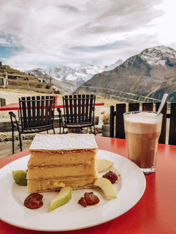
With new energy it's then time to tackle the rather steep descent towards Alp Languard. If you need more motivation than the sheer beauty of nature which is constantly surrounding you, bear in mind that the next delish meal already awaits you...Alp Languard is famous for its tremendous slice of cream cake ("Cremeschnitte"). It is highly recommendable to share a piece at least between 2. You will thank me later...


It's the perfect ending to a perfect hike. To get back down to Pontresina, either take the chair lift from Alp Languard or add another 800 meters of descent until you reach the village.
Tip: If you are staying in a hotel or youth hostel in the Upper Engadine for at least 2 consecutive nights (during the summer season), you will get a card which allows you to use the public transportation as well as most of the mountain railways for free. This is extremely good value, since the means of transportation are rather expensive to use.
5 VAL FEX

DETAILS
Type of Hike Roundtrip
Start / End Sils Maria, Posta
Duration ca. 4.30 hrs
Length ca. 12.5 km
Ascent / Descent ca. 700 hm each
Difficulty medium (T2)
The hike through Val Fex has been on my Engadine bucket list for many years.
On a spontaneous, short getaway in autumn, I finally made it to this stunning, rather open valley near Sils Maria.
From the bus stop Sils Maria, Posta you will first stroll through the cute village itself where you can admire typical buildings of the Engadine. Most of the village is car-free.
Once you reach the village square you will start your hike on the hiking trail along the gorge (Schluchtweg). The trail is gradually ascending, however in a very moderate way.
You will soon pass some small settlements and individual houses, as a few people are living in the valley. The path is leading through nice forest areas and along open meadows and after about 6 kilometers you will reach Alp da Segl. From there, you can either directly take the ascent to Muott'Ota or as we did, first continue straight towards Alp Muot Selvas. The road to Alp Muot Selvas however is a dead end, so you will have to walk the same way back to Alp da Segl.
The scenery is breathtaking, with golden larches, randomly scattered on both sides of the valley and a backdrop of snow-covered mountains. It's well worth the short detour.
The ascent to Muott'Ota is then rather sweaty as you will climb about 500 meters of altitude difference. Try to get slowly but steadily and don't forget to take a look back from time to time.


The views from Muott'Ota will reward you for any effort, as you will get a 360° panorama over the Val Fex and the enitre lake district of the Upper Engadine. An absolutely marvellous scenery!
From Muott'Ota it is then about a 90-minute downhill hike all the way back to Sils Maria.
6 VIA ENGIADINA, SECTION GREVASALVAS - SILVAPLANA

DETAILS
Type of Hike Oneway
Start / End Maloja, Plaun da Lej / Silvaplana, Camping
Duration ca. 3.15 hrs
Length ca. 11 km
Ascent / Descent ca. 480 hm / ca. 460 hm
Difficulty easy to medium (T1-T2)
This hike consists of the major part of the first stage of the Via Engiadina. Due to limited time we decided to start the hike at the bus stop Maloja, Plaun da Lej. From there it is a first moderate ascent until you reach the little village Grevasalvas, perfectly located on a sunny plain. It is also one of the famous filming locations of the movie "Heidi" from 1978.
From up there, you get already amazing views over Lake Sils. Once you are done exploring the traditional mountain village, take the path further up towards Sils and Silvaplana. It leads you along a very panoramic trail which offers you constant lake and mountain views. Especially the contrast between the golden larch forests and the turquoise-blue lakes made me speechless. It is probably one of the most scenic hikes along the lakes of the Upper Engadine.
The most perfect spot for a rest, for taking pictures or for simply admiring the beautiful surrounding is just above Sils, where you will find several wooden benches with unobstructed views over Lake Sils and all the way towards Piz de la Margna in the back.


Take your time to continue the hike all the way to Silvaplana, which is famous for kitesurfing on the lake. The first stage of the Via Engiadina ends at the bus stop Silvaplana, Camping. It's a good opportunity to enjoy a drink or an ice cream in the camping restaurant, which is located directly at the shores of Lake Silvaplana. On top you can observe the hustle and bustle on the lake.
7 BERNINA SUOT - CASCADA DA BERNINA - MORTERATSCH GLACIER

DETAILS
Type of Hike Oneway
Start / End Bernina Suot / Morteratsch
Duration ca. 2.30 hrs
Length ca. 10 km
Ascent / Descent ca. 160 hm / ca. 370 hm
Difficulty easy (T1)
The start of this hike is at the train station Bernina Suot. Alternatively, you can also commence at Ospizio Bernina to get to see the stunning Lago Bianco, however, in that case it's an additional 7 kilometres of walking.
It is a rather flat hike, ideal all year round (except in the midst of winter). The major part of the path follows the beautiful Ova da Bernina, which meanders through the colourful plains and from time to time along the train tracks of the Rhaetian Railway.
Just before reaching Morteratsch train station, the mountain stream plunges over several cascades down to the valley and provides a wild romantic and dramatic scenery. The new waterfall trail was opened only recently, in early summer 2020 and offers different viewing platforms to observe the rushing waters.
Once you reach the end of the waterfall trail you can either decide to have a drink (or lunch) on the sunny terrace of Hotel Morteratsch from where you can enjoy the view towards the snowy mountains, or you continue your hike all the way to the foot of the glacier. This part of the walk is again rather flat and continuously offers the most amazing alpine scenery. Along the path you will find several signs with information about the receding glacier. The glacier trail from Morteratsch train station to the foot of the glacier is a oneway path, so you will have to walk the same way back.


It is a great and easy hike with many natural and informative highlights, perfect also for the entire family.
8 VAL TRUPCHUN

DETAILS
Type of Hike Roundtrip
Start / End S-chanf, Parc Naziunal
Duration ca. 4 hrs
Length ca. 14 km
Ascent / Descent ca. 580 hm each
Difficulty medium (T2)
The Val Trupchun is a stunning side valley of the Swiss National Park, especially worth a visit in autumn, when the larches turn golden and the chances to spot wildlife are fairly good.
It is quite easy to do a roundtrip without having to walk the same way twice. Just make sure that you always walk on the right side of the river "Ova da Varusch". The trail into the valley leads you through beautiful coniferous forest, with larches and pines. It is gradually ascending without any distinctive inclines.
Just before reaching the Alp Trupchun you will have to cross a small, wooden bridge after which you will find a designated area for picknick as well as wildlife observation. It is important to stick to this area, especially when picknicking, as you are within a national park. Dogs are not allowed.
The way back from Alp Trupchun follows again the river, but as mentioned before, on the other side (valley road). You will pass by the park hut "Varusch" which offers a sunny terrace, ideal for a break to soak up some more sunshine before heading back to the point of origin.


I highly recommend to either go on this hike towards end of September during stag rutting season or mid-October for Swiss indian summer.
9 LÄGH DA CAVLOC

DETAILS
Type of Hike Roundtrip
Start / End Maloja, Cad'Maté
Duration ca. 2.45 hrs
Length ca. 9 km
Ascent / Descent ca. 400 hm each
Difficulty medium (T2)
This is another mountain lake jewel which is absolutely worth the visit. Actually, there are two beautiful lakes, but "Lägh da Cavloc" is probably the one better known...
From the starting point you have to follow the main street for about 500 metres until you reach the Maloja pass parking. The first distinctive sign you will encounter is the Orlegna dam which is mainly used by climbers for practise.
After the dam a dreamy mountain path will bring you up to the idyllic mountain lake "Lägh da Bitabergh". Once you surrounded the lake, the trail continues through open forest over a small hikers pass all the way to the highlight, "Lägh da Cavloc".
It's absolutely worth to circumnavigate the lake and make as many stops as possible to enjoy the reflecting mountain scenery in the lake. There are also several fireplaces, perfectly located to have a barbeque picknick. If you don't want to bring your own food, there is a lovely restaurant with a great terrasse to fuel up.
And for the really tough ones, there is even the opportunity to take a dip in the lake. Just be prepared that the water temperatures will be very refreshing...


Afterwards, it's time to start your way back. The best option is the wide forest road that brings you all the way back to Maloja.
Tip: It is also a suitable hike for families with children, as the first part is a themed trail which is all about the smugglers of Maloja. You can even search for treasures...
10 MALOJA - LUNGHINPASS - BIVIO

DETAILS
Type of Hike Oneway
Start / End Maloja, Posta / Bivio, Posta
Duration ca. 5.30 hrs
Length ca. 14.5 km
Ascent / Descent ca. 900 hm / ca. 950 hm
Difficulty medium (T2)
This spectacular hike brings you to the only triple watershed in Europe, from where the water flows via the Inn and the Danube into the Black Sea, via the Julia and the Rhine into the North Sea, and via the Mera and the Po into the Mediterranean Sea.
From Maloja it is a rather steep ascent up to Lägh dal Lunghin. At first, you will get to enjoy breathtaking views over the lake district of the Upper Engadine. Once you get closer to the lake and the watershed, expect a landscape characterised by debris and rocks. The lake looks like a blue gem in the middle of a rather sparse environment.
Once you reach the top of Lunghin Pass, take a rest from the rather exhausting ascent and enjoy the view.
You will then continue the hike via Pass da Sett to Bivio. Here, the landscape is very picturesque with alpine meadows and mountain streams. From time to time you will have to cross some cow paddocks.


From Bivio you will be able to take the bus back via Julier Pass to the Upper Engadine. Make sure to check the timetable in advance to not miss the last bus.
Comments